Start: Durango, Colorado
Finish: Salida, Colorado
Distance: 256 miles Total to date: 4644 miles
Campground: RV Park, Salida Colorado $30.00 for a tent site. Best we could do on short notice
Gas: Durango, Colorado 1.67 gal @ $2.989 $5.00; Montrose, Colorado 2.758 gal @ $2.899 $8.00; Salida, Colorado 3.098 gal @ $3.019/gal $9.35
Park Fees: No fees again today...Hoorah!
Well, it was a bitterly cold night last night and I had to get up and get an extra blanket to cover me in my mummy sleeping bag. We're definetly out of the hot, hot desert. We had a bit of a late start as we had quite a bit of company before we left. There was a retired couple from California that really, really liked to talk. We also talked with a couple from Texas that were on tour and they were almost as chatty. Before we left Durango, we rode down the main street to get a flavour of Durango. It's a busy town that is trying to use the old town atmosphere theme to get tourists. Didn't see to much downtown as it was Sunday, but yesterday, the downtown was bustling.
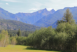
We headed north on Hwy550, also known as the Millionaire Highway due to its rich mining history. It goes through the San Juan Mountains, the wildest and ruggedest peaks in the Colorado Rockies and starts a bit north of Durango, some say it starts at Silverton and ends in Ouray. This was the start of possibly the most scenic route of the trip.
The mountains were getting high around Silverton and fall was in the air. You could see the colours of the leaves changing to their fall colours. Just before Silverton, I stopped at a pullout overlooking the town and everything in the town looked so miniature from my vantage point.
The ride is exciting, because the country is so beautiful, the mountains high and the ride along steep inclines that have no guard rails make it a bit intense at time. There are guard railed pullouts and other pullouts to take photos from. The switchbacks are severe and the speed is low but the views are fabulous. The most intense part of the ride took place at Red Mountain. Luckily we were riding on Sunday as the road was closed most of the day during the week due to construction. In one climb, I remember looking almost straight down at a puny looking transport, far below.
We stopped in Silverton for a few moments and then continued on our way. About 80 miles down the road, was the end of the Millionaires Highway, but this is where all the construction was being done. There, there was a very steep ride down, with a few single lane stops. I recall seeing how they were fixing the outside lane and it was sheer cliff at the edge. Where they were repaving had absolutely no shoulder...it was just a vertical drop.
We stopped for photos of an old mining area at Red Mountain. There was a small mining shaft building and some old tressels. The mountain was blood red and the banks of the creeks below were a bright orange. Beautiful!
You might have thought I did not have a camera due to all the great photos that I missed. However, it took us a long time to get to Ouray because of the photo stops I did make...wish I had the opportunity to take a lot more. We were wondering if we would ever make it to our next destination for the night. However, once we got out of Ouray, the scenery flatten out and we rode a smooth, quick ride to Montrose.
From Montrose, we took Hwy 50 eastward. This was an amazing ride even though we were out of the mountains. We seemed to be in a semi-arid area where the big hills had virtually no trees and were either covered in thin grass or sage. It was pretty. The ride was super. I don't think we had a straight section of highway. We rode long curves after curves up the hills and long curves after curves down the hills. It was so smooth and relaxing.
Past Montrose, we rode past the Curecanti National Recreation Area which is a series of man-made reservoirs. The striking blue water against the barren big hills was a beautiful contrast. The Blue Mesa Reservoir is Colorado's largest body of water and was created by the Blue Mesa Dam. It is about 20 miles long. There are 2 other large reservoirs in the area.
Once we got to Gunnison, we could see bigger hills and soon we were back into the high mountains. The largest we climbed today was Monarchs Pass, almost 11,000 feet above sea level. It was a long ride down for the next few miles.
It was starting to get a bit late, so we decided to stop in Salida for the night. As we entered the valley where Salida is, the whole area looked like it was in a big fog. I guess the fogginess was due to the forest fires in Utah, Nevada or California.
Tomorrow will be our last day in the mountains as we will take a scenic route to Loveland and then I guess we will be Interstating it back home for the quickest route.
So, here's my blog...we made it thru the Millionaires Highway and it was quite the ride!
Subscribe to:
Post Comments (Atom)


No comments:
Post a Comment